Global Circulation
In previous modules, you learned about the role of the Sun in providing heat energy to Earth systems. This energy also drives global circulation which, in turn, redistributes energy and water around the globe.
The Hadley Cell
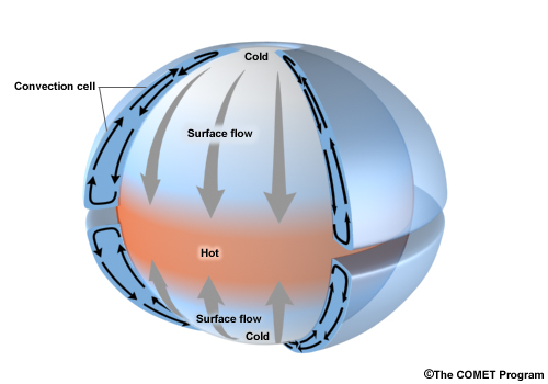
The maximum amount of surface heating on Earth tends to occur near the solar equator, or the latitude at which the sun is directly overhead at local noon. The intense surface heating allows for air parcels to expand, become less dense and eventually rise through convective motion. As parcels of air near the earth's surface rise they cool and eventually reach the lifted condensation level where the air temperature and dew point temperature are equal. You can probably guess what happens next... Yes, clouds can begin to develop.This upward motion continues until it reaches the tropopause at which point air parcels are deflected northward and southward. As this motion results in a net divergence of air away from the solar equator, the amount of airmass pushing down at the surface decreases and creates a surface low pressure.
Meanwhile, the exact opposite circulation arises at the poles where surface temperatures are extremely cold and air parcels condense and are quite dense. The accumulation of air parcels at the pole creates a surface high pressure. One of the main goals of the atmosphere is to redistribute heat, moisture and pressure. In doing so, air masses generally want to flow from high pressure to low pressure in an attempt to balance things out. Surface air originating from the poles converges over the solar equator in what is called the Intertropical Convergence Zone.
On a global scale, this circulation will want to bring surface flow from the polar regions toward the Intertropical Convergence Zone and have a return flow that rises vertically near the solar equator, flows poleward and then sinks over the polar cap.
This phenomenon is known as the Hadley circulation.
The Hadley Cell
The maximum amount of surface heating on Earth tends to occur near the solar equator, or the latitude at which the sun is directly overhead at local noon. The intense surface heating allows for air parcels to expand, become less dense and eventually rise through convective motion. As parcels of air near the earth's surface rise they cool and eventually reach the lifted condensation level where the air temperature and dew point temperature are equal. You can probably guess what happens next... Yes, clouds can begin to develop.This upward motion continues until it reaches the tropopause at which point air parcels are deflected northward and southward. As this motion results in a net divergence of air away from the solar equator, the amount of airmass pushing down at the surface decreases and creates a surface low pressure.
Meanwhile, the exact opposite circulation arises at the poles where surface temperatures are extremely cold and air parcels condense and are quite dense. The accumulation of air parcels at the pole creates a surface high pressure. One of the main goals of the atmosphere is to redistribute heat, moisture and pressure. In doing so, air masses generally want to flow from high pressure to low pressure in an attempt to balance things out. Surface air originating from the poles converges over the solar equator in what is called the Intertropical Convergence Zone.
On a global scale, this circulation will want to bring surface flow from the polar regions toward the Intertropical Convergence Zone and have a return flow that rises vertically near the solar equator, flows poleward and then sinks over the polar cap.
This phenomenon is known as the Hadley circulation.
There are several flaws with this circulation however. You might consider whether the winds at the surface in Idaho always blow from the North while the winds in the upper-troposphere always blow from the South. One of the main flaws with this model is that it does not account for the fact that the Earth rotates about it's axis and the Coriolis Force steers the wind to the right in the Northern Hemisphere, and to the left in the Southern Hemisphere.
Three-cell Model
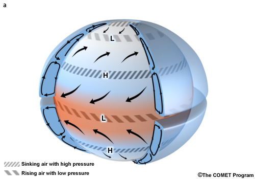
A more realistic model of the general circulation of the atmosphere is the 3-cell model. This includes the Hadley cell; however it is confined to the subtropics between approximately 30-degrees North and South of the solar equator, with a similar circulation located over the pole. Let's start at the equator and move poleward is describing this 3-cell model.
Surface winds that approach the Intertropical Convergence Zone are deflected by the Coriolis force resulting in northeastern winds in the Northern Hemisphere and southeasterly winds in the Southern Hemisphere. These winds are called trade winds as they were often a reliable way to navigate the seas for ships heading west.
The descending branch of the Hadley Cell is located approximately at 30-degrees North and South latitude. Here air descends and results in a surface high pressure system. Near these surface high pressures the air is warm, skies clear, and winds generally light. Sinking air not only results in compressional warming, but also inhibits cloud and precipitation formation. Not surprisingly, many of the world's desert biomes are located in these latitudes.
Poleward of the subtropical high pressure surface winds head poleward and westward giving rise to surface westerly in the mid-latitudes that we live in. These midlatitude surface westerlies eventually meet up with eastward and equatorward flow air from the pole. The intersection of these two air masses: one, extremely cold and dry, the other relatively warm and moist, typically results in frontal uplift and midlatitude cyclones that we often experience. The convergence of these two air masses results in rising motion and completes the 3-cell model.
This model is better, but still doesn't totally resemble circulation on our planet. What is missing?
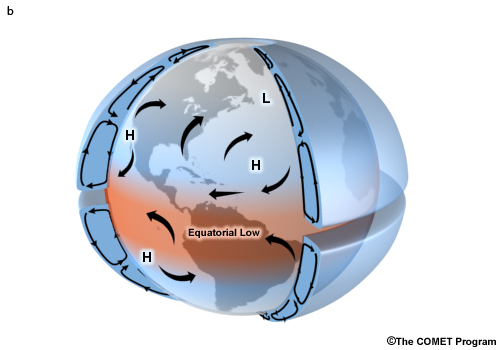
Continents of course. Land masses respond differently to heating than to water bodies, as they heat up and cool down much faster. Similar to the concepts outlined above on the origin of the Hadley circulation, different rates of heating over the continent versus land during the summer months, results in the development of a surface low pressure over land and high pressure over the oceans. Let's take a look at global average sea level pressure during the summer months (contours) and corresponding surface wind (arrows).
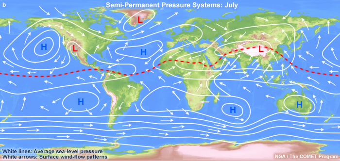
Note the strong surface low over Asia and to a lesser degree over N. America, in contrast to the surface high pressure over the North Pacific and Atlantic oceans. The red dashed line shows the general position of the Intertropical Convergence Zone. In general it moves northward over continental land masses due to the strong surface heating of the summer months.
Contrast the Southern Hemisphere to the Northern Hemisphere. The relative lack of continents results in a more symmetric circulation with strong surface westerlies south of 35-degrees south and surface high pressure located along a latitudinal band near 20-degrees S.
Contrast the Southern Hemisphere to the Northern Hemisphere. The relative lack of continents results in a more symmetric circulation with strong surface westerlies south of 35-degrees south and surface high pressure located along a latitudinal band near 20-degrees S.
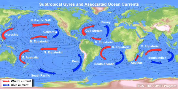
Surface Ocean Currents
Surface ocean currents are guided by surface winds. You can think of this as the winds pushing on the surface of the ocean and directing the flow parallel to the winds. Large scale ocean currents thus reflect overlying surface wind and atmospheric pressure patterns. Over all of the subtropical ocean basins there is a large gyre (or circulation) that develops corresponding to the surface high pressure and anticyclonic winds. These gyres tend to bring warmer warmers poleward along the western boundaries of continents (e.g., the Gulf Stream off the Atlantic coast of N. America) whereas currents along the eastern boundary of ocean basins bring cold water equatorward (e.g., California current off the Pacific coast of N. America).
Log in to BBLearn, and under Module 5, go to the Study Area. In the 'Interactive Animations,' select 'Global Wind Patterns with Hadley Cells' under Chapter 5 and interactive animation "Ocean Circulation" under Chapter 4. Use the animation to help you complete "Assignment 5.1: Atmospheric circulation and pressure"
