Columbia Plateau Basalts
Like Craters of the Moon, the Columbia Plateau is a volcanic landscape. But unlike Craters of the Moon, where the lava flows are relatively well-defined and associated with a distinct hot spot (Yellowstone), the Columbia Plateau flood basalts are much harder to pin down to a specific origin. They are also likely associated with a mantle plume hot spot, although it is uncertain whether the Yellowstone hot spot or an earlier iteration of it is behind their formation.
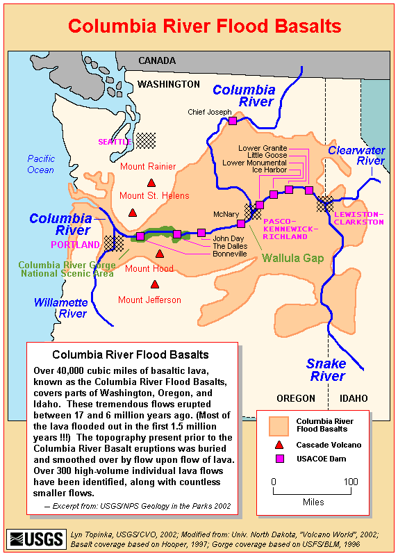
Flood basalts are so named because such a large amount of lava emerges from a crack in the lithosphere at once that it literally "floods" across the landscape. In the case of the Columbia Plateau, there were at least 300 "flood" events over millions of years. The most extensive of these floods reached all the way to the Pacific Ocean, covering a distance of several hundred miles. As layer after layer of basalt flowed out and hardened, the thickness of the basalts grew to be more than 6,000 feet thick in places. These basalt flows cover much of eastern Washington and Oregon, with small intrusions into northern Idaho. The map below shows both the extent of the flood basalts across the region, as well as the major river canyons that cut through the basalts and make them so visible.
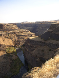
In much of eastern Oregon, the flood basalts are not easily visible, but are instead buried under hundreds to thousands of feet of sediments that accumulated over the millions of years following the end of the volcanic period. In eastern Washington and through both the Snake and Columbia River canyons, however, the flood basalts are visible everywhere. As towering cliffs along the rivers, stepped hillsides, and hexagonal columns on roadside outcrops that are used in building and landscaping throughout the region. Why can we see the basalts so easily here?
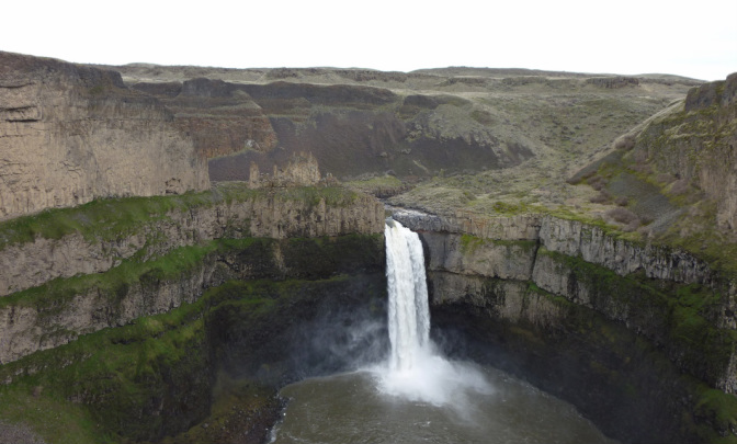
Palouse Falls State Park near Washtucna, WA. A great place to see exposed basalt flows.
The high visibility of the basalt flows in Washington and Idaho is the product of the last ice age. Between 10,000 and 20,000 years ago, there was a huge lake filling the Clark Fork Valley, where the city of Missoula, Montana sits today. Known as Lake Missoula, it formed when the continental ice sheet dammed up one end of the valley, and contained more water than present day Lakes Erie and Ontario (the two smallest Great Lakes) combined. When the ice dam suddenly broke, the flood waters were released on a biblical scale, rushing headlong into the Columbia River canyon and scouring the sediments from atop the basalt plateau. Today, there is much visible evidence of this flood and several subsequent ones around the region, but perhaps the best view is from the sky, where both aerial photos and satellite imagery show the scouring patterns from the flood that are known in Washington as the Channeled Scablands (below). Throughout this region, the Columbia Plateau flood basalts are widely exposed.
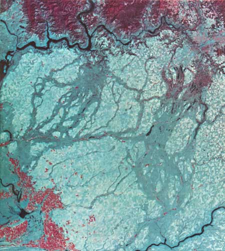
The Channeled Scablands in a false-color remotely sensed composite image from 1972. The bright red areas are irrigated agriculture around the Tri-Cities.
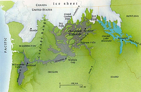
Depiction of how the continental ice sheet repeatedly dammed Glacial Lake Missoula during th last ice age, and the extent of the Channeled Scablands whenever the ice dam broke and released a giant flood of water.
