Floods
Floods are one of the oldest known natural hazards for humans across the globe, particularly since early humans specifically built their civilizations next to rivers, and today, many of the largest cities globally occur at confluences of rivers. While flooding is an ongoing threat to mankind, however, humans have developed some impressive mitigation measures to reduce the negative impacts of flooding in areas that are prone to it. In Module 4, you learned about the natural development of floodplains and levees. Now, let's look at how humans have altered floodplains to address this hazard, and what types of questions scientists are asking about these long-term impacts of these alterations.
The Mighty Mississippi
In 1927, the most destructive flood in US history happened along the Mississippi River and its tributaries, leading to the Flood Control Act of 1928. This Act sought to build a system of levees and river controls that would prevent future catastrophic floods by keeping the Mississippi River confined within its banks. While there have been several large floods in the intervening years, including the great flood of 1993, the system has been largely successful at reducing the danger of flooding to humans. It does so with three main features:
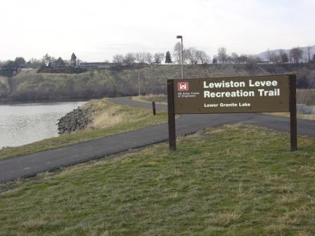
1) Levees: like naturally-occuring levees, these artificial ones are essentially earthen walls, sometimes reinforced with concrete and other stronger materials, particularly around large cities. Levees keep rivers in their existing channel, and don't allow rivers to meander into new channels. A good example of a levee system is found only 30 miles south of Moscow, where the city of Lewiston, Idaho is protected from the Clearwater and Snake Rivers by a levee system. Since the confluence of the Snake and Clearwater Rivers is almost always higher than downtown Lewiston, the downtown area would be completely flooded if the levee broke!
1) Levees: like naturally-occuring levees, these artificial ones are essentially earthen walls, sometimes reinforced with concrete and other stronger materials, particularly around large cities. Levees keep rivers in their existing channel, and don't allow rivers to meander into new channels. A good example of a levee system is found only 30 miles south of Moscow, where the city of Lewiston, Idaho is protected from the Clearwater and Snake Rivers by a levee system. Since the confluence of the Snake and Clearwater Rivers is almost always higher than downtown Lewiston, the downtown area would be completely flooded if the levee broke!
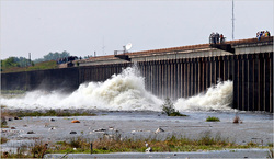
2) The Morganza Spillway: this structure acts like a dam, but along the sidewall of the river. It alleviates pressure on the lower Mississippi by diverting river water into the Atchafalya floodplain. The Morganza Spillway is, in essence, a "back-up plan," and has only been opened twice in it's 70-year history: 1973 and 2011.
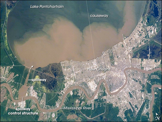
3) The Bonnet Carre Spillway: much like the Morganza Spillway, it diverts water out of the lower Mississippi. However, the Bonnet Carre Spillway sits only a few kilometers upstream of the city of New Orleans, and it diverts water into Lake Ponchartrain, the large lake that bounds New Orleans on the north side. This spillway is opened much more frequently. The amount of sediment being carried by the Mississippi River is especially high during a flood, and the satellite image below shows how the water diverted by the spillway carries that sediment into the lake.
In 2011, this system was put to the test during the greatest Mississippi flood event to happen since 1927. Both the Morganza and Bonnet Carre Spillways were opened in order to protect the cities of Baton Rouge and New Orleans from flooding. In the process of opening the spillways, the floodwaters were allowed to carry thousands of tons of sediments into marshlands along the coastline that had been subsiding, or sinking, ever since the river was confined and no longer allowed to flood. For scientists, the event provided an opportunity to better understand how protecting humans from river flooding harms wetland ecosystems and ultimately imperils coastal areas during hurricanes (which historically were buffered by the extensive coastal wetlands) -- in essence, the mitigation of one hazard increased the potential damage from another in Louisiana. Watch the USGS video below and answer the questions that follow.
1) Why are USGS scientists studying sediments associated with the 2011 flood event?
2) Approximately how large of an area of wetlands has been lost along the Louisiana coast since the system was put into place in the 1930s?
3) Why are the Atchafalaya Delta wetlands and marshes more stable and healthy than the wetlands further east in the Mississippi Delta (also called a 'birdsfoot' delta for its shape)?
4) How can scientists tell the new sediment deposits from the old sediments? What is present in the older sediments?
5) What is the process by which marshes develop associated with floods?
6) Based on the amounts of sediment found across the area sampled after the 2011 flood, which region do you think will be better able to buffer the effects of future hurricanes (such as storm surges): the Atchafalya Delta or the Mississippi Delta?
7) Besides flood control, why do you think humans want to keep the Mississippi in its current channel going through New Orleans and Baton Rouge (HINT: what do you see on the river in the video)? What do you think would happen to those cities if the Mississippi were allowed to leave its current path and move into a new one further west (as it wants to do)?
