Tropical Cyclones and Hurricanes
When most people think of Florida, they think of sunny beaches, palm trees, and vacation destinations associated with the state. When meteorologists think of Florida, however, usually they are thinking about hurricanes. More than just the mascot of the University of Miami, hurricanes have shaped the state and its settlement patterns for hundreds of years. They also produce more widespread damage along the eastern coastline of the US than nearly any other natural hazard due to their relatively slow speed, wide extent, and associated flooding.
How do hurricanes form?
Hurricanes have humble beginnings as simple thunderstorms that brew in the subtropical oceans of the world. Warm air and moist air near the surface support the development of rising air and clouds. Such clouds of typical of the tropics where ocean temperature are sufficiently warm. Individual thunderstorms may often become organized and conglomerate together creating a tropical disturbance. Such disturbances are relatively common, yet not all disturbances evolve to form a tropical storm or hurricane. Rather, a set of ingredients have to be in place to allow a humble group of thunderstorms to grow into a beast.
The ingredient list
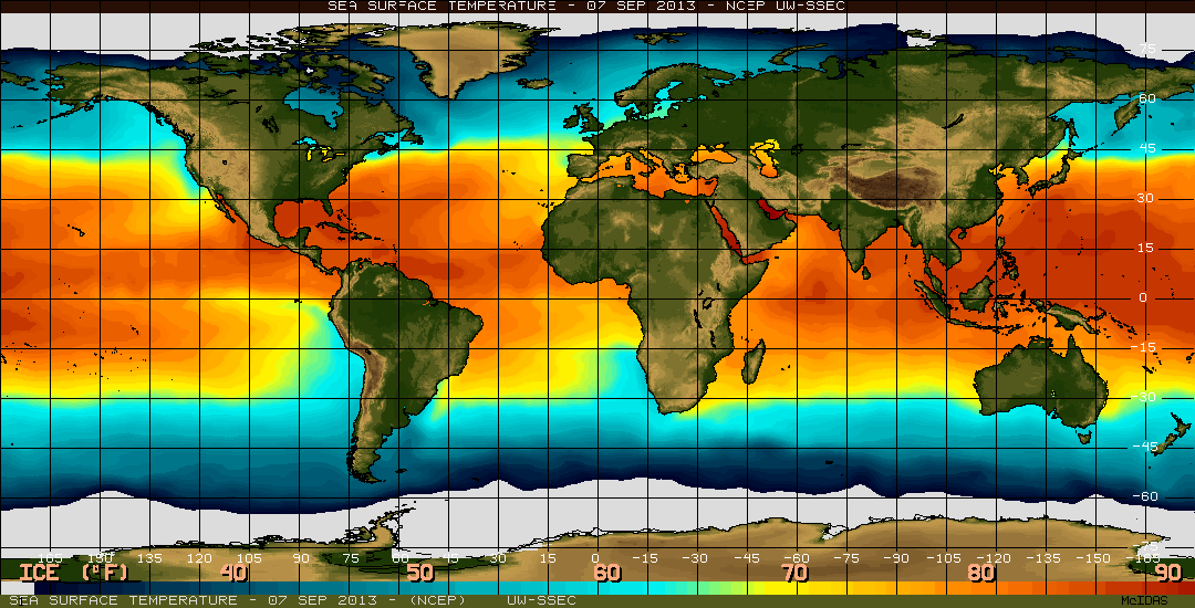
As geographers, we can identify regions and times of the year when these conditions align. Let's first take a look at sea surface temperature from early September. Regions in orange denote breeding grounds or waters that can encourage tropical storm development. You can examine current sea surface temperatures through this link.
Hurricanes have humble beginnings as simple thunderstorms that brew in the subtropical oceans of the world. Warm air and moist air near the surface support the development of rising air and clouds. Such clouds of typical of the tropics where ocean temperature are sufficiently warm. Individual thunderstorms may often become organized and conglomerate together creating a tropical disturbance. Such disturbances are relatively common, yet not all disturbances evolve to form a tropical storm or hurricane. Rather, a set of ingredients have to be in place to allow a humble group of thunderstorms to grow into a beast.
The ingredient list
- Very warm ocean surface temperatures exceeding 27C (80F)
- Warm water extends to at least 150 feet deep
- At least 5-degree latitude poleward of the Equator
- Moist and unstable atmosphere
- Weak winds at higher elevations (or low wind shear)
As geographers, we can identify regions and times of the year when these conditions align. Let's first take a look at sea surface temperature from early September. Regions in orange denote breeding grounds or waters that can encourage tropical storm development. You can examine current sea surface temperatures through this link.
Primary Development Regions
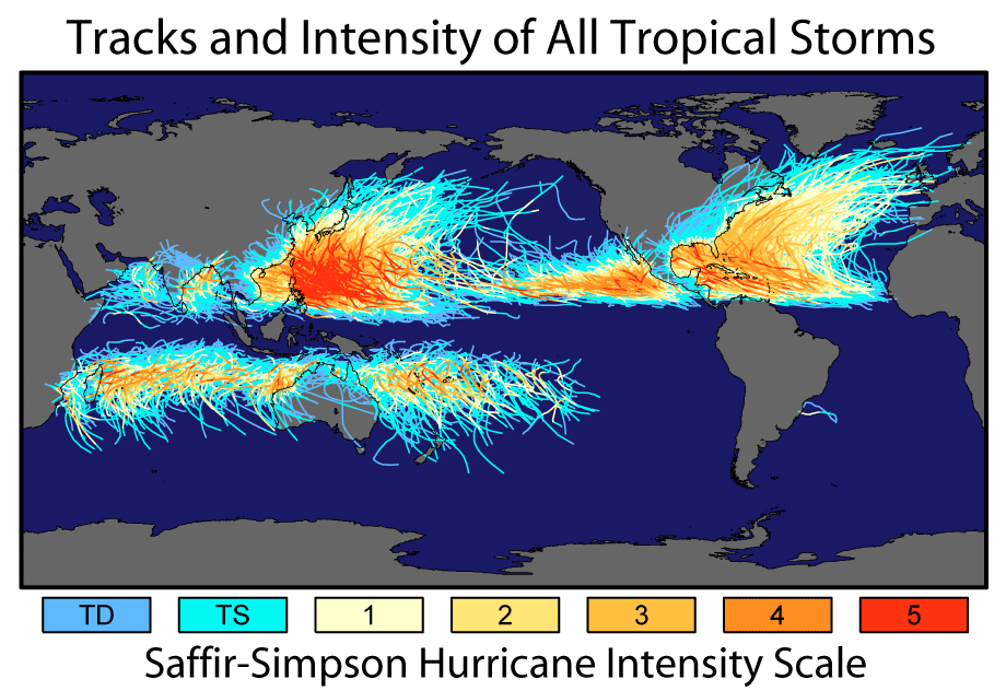
A historic look at tropical cyclone tracks yields several preferred regions. The nomenclature of tropical storms varies by region, with strong storms in the western Hemisphere known as Hurricanes, those in the northwestern Pacific Ocean known as typhoons and storms in the south Pacific and Indian oceans known as cyclones.
Compare the tracks of tropical storms with the map of sea surface temperature above. Note the lack of storms on the equator, the south Atlantic, southeast Pacific and relative lack of storms tracking northward of the US-Mexico border along the west coast of North America. Water temperatures are simply not warm enough in these regions to allow for storms to persist. Recall why ocean temperatures on the west coast of the US are so much colder than those at the same latitude on the east coast of the US.
Secondly, note the general trajectory of such storms: they begin at low latitudes, move westward following the trade winds toward the warmest waters that hang out in the western ocean basins and generally curve anticyclonically poleward (clockwise in the Northern Hemisphere). The strongest storms, indicated by the red lines tend to form in the western Pacific and to a lesser degree in the North Atlantic near the Caribbean.
Tropical Cyclone Hazards
Three primary hazards of tropical cyclones include:
(1) Wind damage
Hurricane force winds refer to sustained winds exceeding 74 miles per hour. Many recent hurricanes and typhoons have had sustained winds over 150 miles per hour, with gusts well beyond that. The winds are not symmetrical around the otherwise symmetrical storm. Rather, the northeastern quadrant tends to pack the biggest punch. Imagine a counterclockwise circulation that moves northward. In the northeast quadrant the northward movement of the storm compound the northward moving winds to create the strongest force. Tornadoes can often be embedded with the outer bands of landfalling cyclones thereby creating additional hazards.
(2) Storm surge
Storm surge describes the rise in ocean levels due to the piling up of water that has been pushed ashore ahead of a tropical cyclone. The strong winds literally push against the ocean surface through frictional processes to slosh vast quantities of water toward land. Click here to view an animation of storm surge. The slope of the shoreline can alter the amount of storm surge. Storm surge will be significantly higher in the northeastern quadrant of a storm where winds are stronger. Storm surge can temporarily "raise" sea level by 15-30 feet in the strongest storms leading to widespread inundation of low-lying areas.
(3) Flooding
Storm surge can lead to widespread coastal flooding. However, after hanging out in warm tropical waters for quite some time tropical cyclones can drop an epic amount of precipitation. The all-time world records for daily precipitation (more than 70 inches in 24 hours) occurred in the South Pacific during a landfalling tropical cyclone. Of particular concern are slow moving tropical cyclones that hit mountainous regions. While weaker than hurricanes, tropical storms in the Gulf of Mexico or Caribbean that move westward before slowing down over the mountains of Mexico, Honduras or Nicaragua have frequently produced 20+ inches of rainfall and resulted in widespread flooding and loss of life over the past decade.
Hurricane warning
Satellite observations are the key to early warning for tropical storms. Images of visible, infrared and water vapor across the global oceans are examined regularly during the warm season for signs of organized development of thunderstorms and tropical disturbances that might yield a tropical storm or cyclone. Due to the lack of widespread surface observations, the National Hurricane Center may often send aircraft to get additional diagnostics on developing systems. These "Hurricane Hunters" capture both instantaneous observations, but also drop weather instruments through a storm to understand winds, temperature and humidity in three-dimensions.
Hurricane forecasts are developed using numerical weather models similar to those used to forecast the weather in your backyard. By using several different forecasts, forecasters can get an estimate of the possible track and intensity of the system through time. Currently, forecasts of hurricane tracks are remarkable accurate; however, forecasting hurricane strength is less well forecasted and understood.
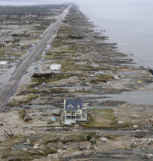
A storm surge from Hurricane Ike in 2008 flattened nearly every home on this peninsula near Galveston, Texas. The mitigation measures taken by the builder of this home saved it.
How do humans mitigate for hurricane impacts?
Vast global population resides in areas subject to tropical cyclone impacts. To mitigate against the rare impacts from tropical cyclones several measures can be taken.
1. Stronger structures, reinforced roofs to meet building code standards.
2. Building coastal homes on stilts
3. Education of the hazards, and evacuation plans
The United States has seen an overall decrease in the loss of human life from hurricanes, while property losses have continued to increase. The impacts of climate change are reasoned to generally increase the strength of winds and overall precipitation rate of tropical cyclones. This coupled with sea level rise suggest that the hazards of hurricanes are not going away anytime soon.
Log in to BBLearn and complete "Assignment 7.5: Tropical Cyclones."
