Tornadoes
Every year, the greatest number of tornadoes anywhere in the world occurs right here in the US, in the region of the midwest known to many as 'Tornado Alley.' Why do such a disproportionately high number of tornadoes happen here? More importantly, how have weather forecasters learned to predict these twisters with enough lead time so that people might have a chance to escape them?
How do tornadoes form?
The proper mix of ingredients need to be in place for a tornado. These include:
(1) strong contrasting air masses (typically cold air to the north, warm and moist air to the south and southeast)
(2) strong lapse rate (warm surface and cold air aloft)
(3) strong wind shear (change in wind speed and direction with elevation): low-level southerly flow and upper-level westerly to northwesterly flow. This change in wind direction with height is key to the development of the rotating column that results in a tornado.
(4) a mid-latitude disturbance
Strong instability in the atmosphere can initiate convection. What distinguishes conditions conducive to tornadoes and those associated with run of the mill thunderstorms is the wind shear. This shear promotes rotation in the vertical (e.g., think of a wind mill) that draws air in called "roll clouds". When the updrafts from these storms become strong enough the rotation can transition to what we know to be tornadoes.
These ingredients are not a sufficient conditions however, as even when everything is lined up, tornadoes may fail to materialize. Thus, tornado watches are issued up to a day in advance when conditions are conducive to tornado development. However, even with technological advances, we can not accurately predict when and where tornadoes will form. Radar can tell us when tornadoes or rotating thunderstorms are active and are the primary means of detecting tornadoes and issuing warnings today.
Why do so many occur in tornado alley/midwest?
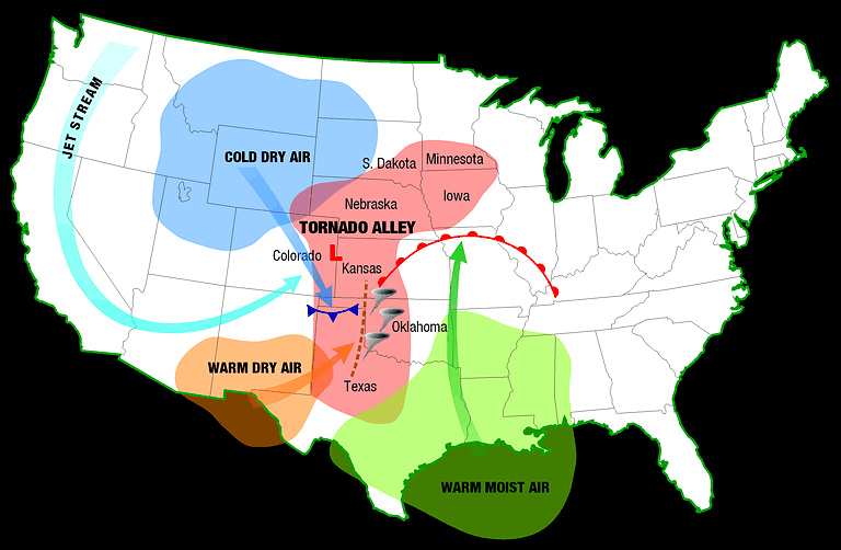
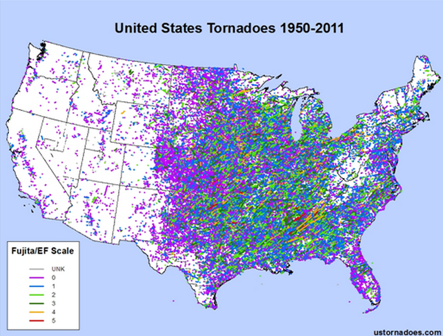
The geographic distribution of tornadoes corresponds to regions likely to experience the ingredients that foster their development. Tornadoes are further favored in regions with low surface friction, since rough surfaces (e.g., mountains) create too much friction to support strong and or long-lived storms. The Great Plains is the preeminent hot spot of tornadoes globally and is dubbed "Tornado Alley". The confluence of three distinct air masses meet in Tornado Alley. The barrier of the Rocky Mountains to the west traps cold air masses that form over interior Canada from spilling westward; warm, moist waters of the Gulf of Mexico to the south are wafted into the region by a low-level southerly flow; warm and dry air that forms over the higher elevations of western Texas pushes up against the warm moist from from the Gulf of Mexico. The contrast of the warm and dry and warm and moist air over Texas and Oklahoma is a regional phenomena called a dry line. This helps further prime the atmosphere for tornado outbreaks.
lead to the perfect storm of temperature contrasts. By spring, snow cover has dissipated from the region allowing for surface temperature to warm substantially helping to further destablize the atmosphere. Finally, the midlatitude westerly jet stream crosses the Rockies to add wind shear to the equation. Tornadic activity wanes into summer as the jet stream moves well northward and temperature contrasts weaken.
Can they happen in Idaho?
Yes! An average of 5 tornadoes are reported each year in Idaho. Similarly much of the western US is a desert for tornadoes, as the ingredients are not typically available for their formation and the rough topography is a hindrance to their development. Late spring and early summer are the peak months for tornadoes to develop in the Northwest.
Look at the history of tornadoes in Idaho through the Tornado History Project website. Has anyone ever reported a tornado in Moscow?
How do we measure tornadoes?
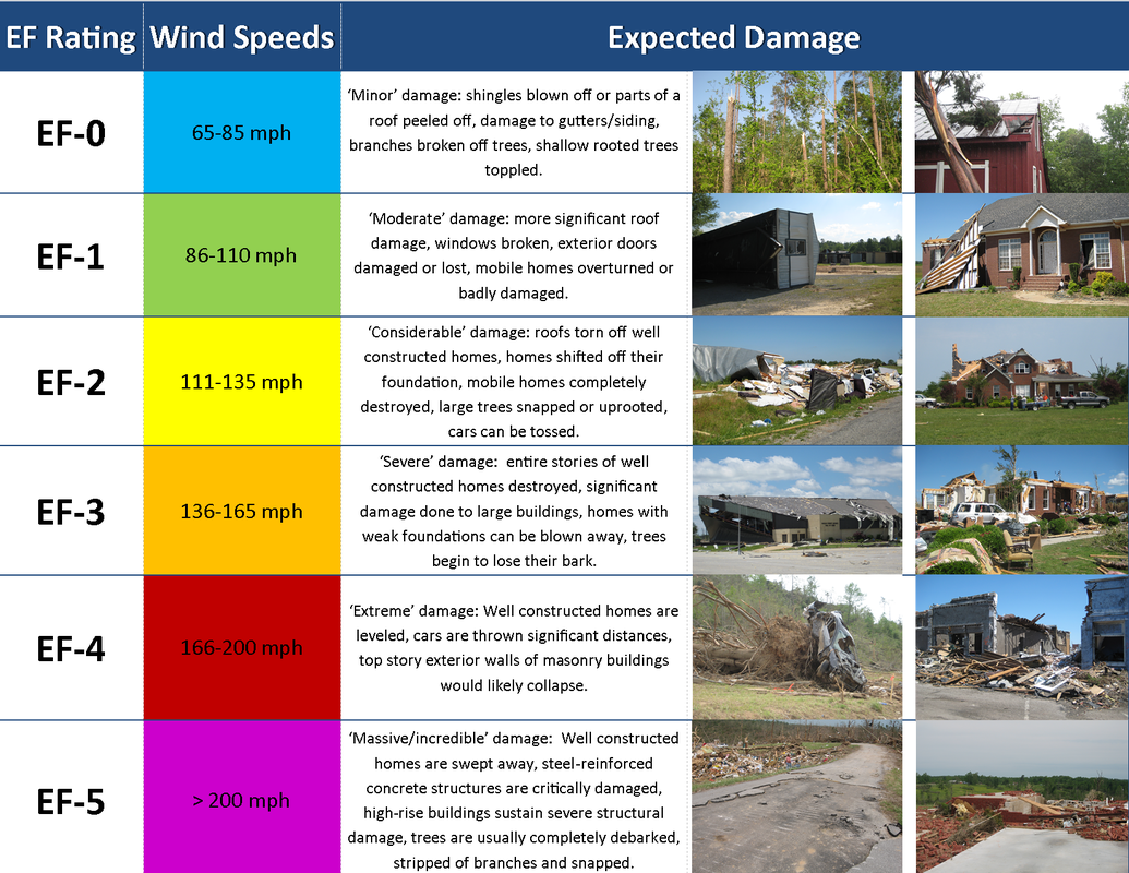
Very carefully. Wind speeds are rarely measured by instruments that live to tell the story. Wind speeds can be measured with Doppler Radar, although this is rather challenging. The most frequent means of measuring wind speed is through the Enhanced Fujita scale. This is done through surveying the affected path of a tornado and assessing the damage in its wake. Since tornado damage can be exaggerated by media reports, a team of experts from the National Weather Service typically is the referee when it comes to deciphering the strength of the storm. An overview of the scale is provided below (from the NWS).
Wonder what the strongest tornado "ever" was? Check out this nice FAQ compiled by the Severe Storms Laboratory.
Tornado Hazard Mitigation
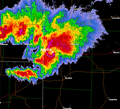
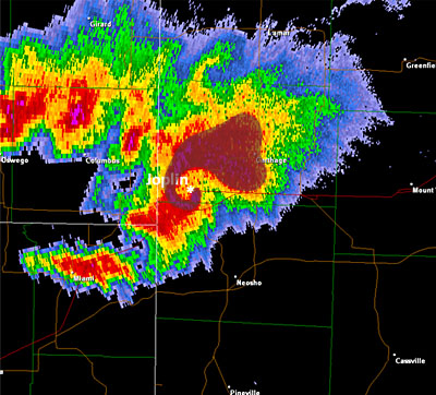
Advances in weather forecasting have improved the ability to predict conditions conducive to tornadoes and particularly large outbreaks up to a few days in advance. Days with particularly large likelihoods are well publicized in the National Media and The Weather Channel has developed its own TOR:CON index that tells of the odds of experiencing a tornado with a 50-mile radius of any given location across the US. Advances in radar detection have increased the amount of lead time for warnings from a few minutes to nearly 15 minutes on average. The images below show radar returns over SW Missouri. Note the hook-like feature near Joplin. This is a tell-tale sign of a rotating thunderstorm and is often corroborated by Doppler radar winds that show strong winds going in opposite directions near the hook.
Advances in weather forecasting have improved the ability to predict conditions conducive to tornadoes and particularly large outbreaks up to a few days in advance. Days with particularly large likelihoods are well publicized in the National Media and The Weather Channel has developed its own TOR:CON index that tells of the odds of experiencing a tornado with a 50-mile radius of any given location across the US. Advances in radar detection have increased the amount of lead time for warnings from a few minutes to nearly 15 minutes on average. The images below show radar returns over SW Missouri. Note the hook-like feature near Joplin. This is a tell-tale sign of a rotating thunderstorm and is often corroborated by Doppler radar winds that show strong winds going in opposite directions near the hook.
|
|
This is obviously not much time, but enough for people who hear sirens to get to a protected area. Unfortunately, despite such advances in technology numerous people are killed each year by tornadoes. In 2011 over 1,700 reported tornadoes in the US killed a total of 553 people, the most since 1953. Granted, the number of people living in areas that receive tornadoes has increased; however, the nature of the hazard with its short lead times, numerous false alarms (tornado watch that failed to materialize), and populations disconnected to their environment means that tornadoes will continue to be a formidable hazard.
Does climate change influence tornadoes?
Climate change might alter the mix of ingredients conducive to tornado formation, although in confounding ways. For example, a warmer atmosphere with more moisture might be more unstable and capable of releasing more energy; however, a reduction in the contrast of cold air to the north and warm air to the south as is projected in a changing climate might weaken the ingredients. Scientists do not have any evidence to suggest tornadoes have changed over the historic record due to the problems of reporting them consistently through time, and do not have widely held and testable theories of how tornadoes might change in the 21st century.
Log into BBLearn and complete "Assignment 7.4: Tornadoes."
