The El Niño Southern Oscillation
El Nino and La Nina are the warm and cool phases, respectively, of tropical ocean surface temperatures of the eastern to central Pacific Ocean (between Peru and approximately the International Date Line). Generally, the eastern tropical Pacific Ocean temperature are relatively cold due to the transport of warm surface water westward due to the trade wind circulation, and the influence of upwelling of cool water along the equator and western coast of South America. Every 2-7 years processes weaken the trade winds and allow for the warm water typically over the western tropical Pacific Ocean to slosh back into the central and eastern basin and cut off upwelling. This unusually warm water has come to be known as El Nino as named by Peruvian fisherman who noted the collapse of the fisheries off their coast in late December during certain years. Besides the influence of fisheries in Peru, the occurrence of El Nino has large-scale implications for global climate.
Normal Conditions
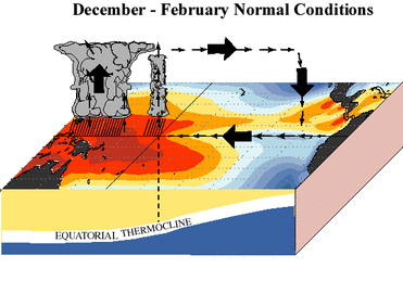
Over warmer waters, above 28°C, convection and clouds often form due to the rising moisture-laden warm air. Convective activity over these warm waters influences more than just the local weather. Rather, this rising motion creates a compensating airflow pattern that transports energy and moisture out of the tropics into the mid-latitudes.
El Nino
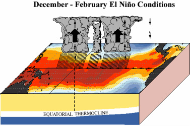
Ocean temperatures in the eastern Pacific are usually too cool to support widespread convection. During an El Nino event, the warm waters over the western Pacific slosh eastward dramatically increasing ocean temperatures in the eastern Pacific and allowing for convective activity to migrate eastward.
La Nina
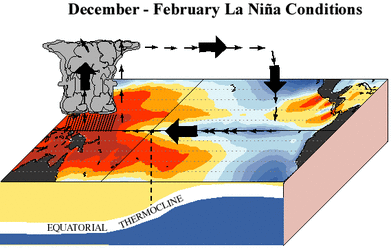
By contrast, the opposite phase of this circulation, La Nina, amplifies the typical trade wind circulation and allows for more warm water to pile up in the western tropical Pacific leaving the eastern tropical Pacific cooler than normal
Teleconnections
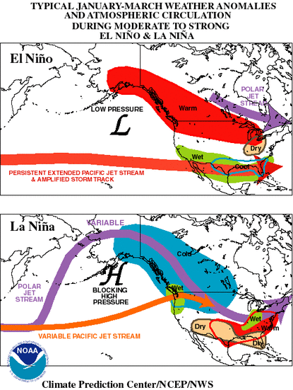
During an El Niño winter, the sub-tropical jet stream strengthens over the southern tier of the US, while the polar jet is forced further north than usual. The stronger subtropical jet brings heavier precipitation across the Southwest, Texas and Florida, while the displaced polar jet results in below normal precipitation over the Pacific Northwest and warmer than normal.
Conversely, during a La Nina winter, the polar jet stream is strengthened leaving the southern tier of the US dry and the northwestern US wetter and cooler than normal.
Conversely, during a La Nina winter, the polar jet stream is strengthened leaving the southern tier of the US dry and the northwestern US wetter and cooler than normal.
Climatologist and oceanographers can reasonably predict the phase and magnitude of El Nino with up to 3-6 months lead time. For current information on the current status of El Nino, visit the Climate Prediction Center.
El Nino is defined along a sliding scale by measuring both how warm ocean surface temperatures are in the eastern and central equatorial Pacific and the sea level pressure difference between Darwin Australia and Tahiti. When ocean temperatures in the eastern tropical Pacific are warm, surface pressure in Tahiti tends to be low thereby weakening the trade winds and allowing for warm water to slosh from west to east across the tropical Pacific.
Note that the presence of an El Niño, for example, does not mean that you shouldn't by a ski pass for the winter. El Niño manifests in a variety of patterns and strengths (sometimes referred to as flavors). For example, the strongest El Niño events will have the largest sea surface temperature anomalies, and cover the equatorial Pacific from Indonesia to South America. These events tend to have strong links to mid-latitudes, and are well known for causing climate extremes and impacts. A weak El Niño may cover a lesser geographic extent, be of weaker strength, and consequently have weak to the mid-latitudes and climate in the US. While statistically, the odds of a mild winter in the Northwest increase substantially during an El Niño, there is no guarantee of it.
Log in to BBLearn, and under Module 5, complete "Assignment 5.5: El Nino-Southern Oscillation"
