Local Winds of the Northwest
The strongest large-scale winds that influence the Northwest are associated with large-scale weather systems that feature both strong surface pressure gradients and a jet stream aloft. On localized scales, smaller scale pressure differences associated with contrasts between water and land, and interactions of upper-level winds with topography can result in local winds.
1) Land-sea breezes (Seattle, WA)
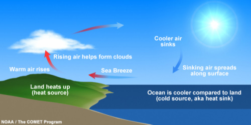
The sea-breeze is nature's air conditioner for those who live close to the ocean. The stronger heating of the land surface compared the the ocean surface during the daytime results in less dense and buoyant air over land and the development of a thermal low pressure. This works in the exact same fashion as the solar equator does in the Hadley cell circulation.
Cooler air over the ocean moves inland due to the pressure gradient force thus providing that nice onshore flow to cool things off near the immediate coast. What do you think happens at night to this circulation?
Cooler air over the ocean moves inland due to the pressure gradient force thus providing that nice onshore flow to cool things off near the immediate coast. What do you think happens at night to this circulation?
2) Mountain-valley winds ( )
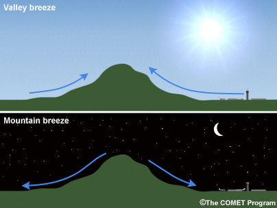
The ground warms and cools faster than the overlying air. This is why you might observed frost on the ground even though the official temperature did not drop below freezing. During the overnight hours the air near the ground cools rapidly. As cold air is more dense that warm air at the same pressure, air that cools on surfaces will tend to migrate downhill following gravity. In mountainous areas, air cooling on a mountain peak will flow down the mountain and into the valley's. Often valley temperatures at night are far colder than at higher elevations.
By contrast, during the daytime hours, warm air near the surface will want to rise through convective motion. Unlike air rising on a flat surface, the rising motion at mountain crests is accentuated and results in a surface low pressure that draws warmer air from the valley upslope. Mountain-valley winds are most noticeable during the summer months when large-scale pressure gradients are absent.
By contrast, during the daytime hours, warm air near the surface will want to rise through convective motion. Unlike air rising on a flat surface, the rising motion at mountain crests is accentuated and results in a surface low pressure that draws warmer air from the valley upslope. Mountain-valley winds are most noticeable during the summer months when large-scale pressure gradients are absent.
3) Downslope Foehn winds (Wenatchee, WA)
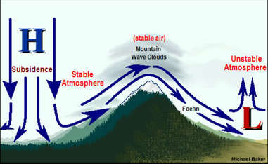
Strong winds often develop in the leeward side of a mountain range. This typically happens when there is a strong pressure gradient across the mountain barrier, and often strongest when coupled with strong winds unrelated to the surface pressure gradient at upper levels of the atmosphere. As air descends a mountain range it undergoes compressional heating. Flow that passes through mountain gaps can be especially potent due to the funneling of air (also called the Bernoulli effect). Downslope winds are very frequent on the east side of the Cascades during summer due to the semi-permanent high pressure over the Pacific and low pressure over the interior. Downslope winds pose significant fire weather threats across much of the western United States, particularly when the surface high pressure originates over a very dry region.
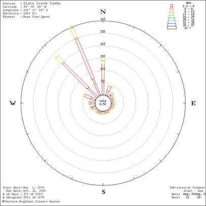
What is a Wind Rose?
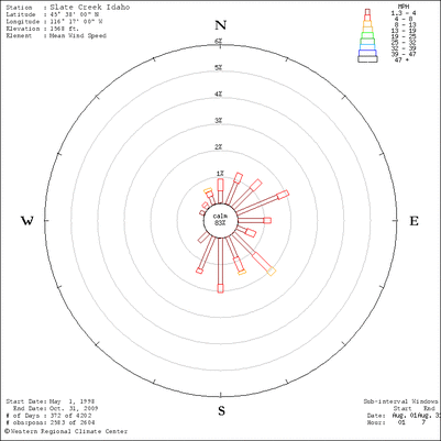
A wind rose graphically shows the frequency and magnitude of wind direction for particular weather stations. It often helps determine the prevailing wind direction as well as the wind direction of the strongest winds, and are often of interested to pilots. The plot shows wind direction with color bands showing wind ranges. The directions of the rose with the longest spoke show the wind direction with the greatest frequency.
The plot here shows a wind rose for Slate Creek ranger station for overnight hours of 1-7AM the month of August. Slate Creek is located just north of Riggins Idaho on HWY-95 located in the Salmon River Canyon.
The plot here shows a wind rose for Slate Creek ranger station for overnight hours of 1-7AM the month of August. Slate Creek is located just north of Riggins Idaho on HWY-95 located in the Salmon River Canyon.
This plot also shows a wind rose for Slate Creek for August. However this is only for daytime hours from 11AM-6PM. What local wind phenomena do you suspect is operating here?
Log in to BBLearn, and under Module 5, complete "Assignment 5.4: Land-Sea breezes"
