Precipitation: Rain, Snow, and Virga, oh my!
While there is ALWAYS water vapor in the air, a series of conditions must occur for that water vapor to undergo a phase change that produces first clouds, then precipitation. This precipitation can take one of many forms depending on the temperature and the level of stability in the air mass.
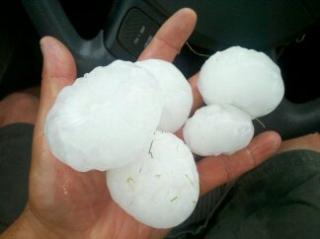
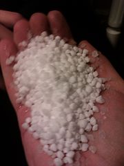
The simplest form of precipitation is rain. When the temperature is below freezing point, precipitation falls as snow. When rain forms and falls, but does not reach the ground, it is called virga. Virga (below left) is most commonly seen in the summer when thunderstorms form over hot land surfaces, and falling rain evaporates before it reaches the surface. Thunderstorms can also produce less frequently seen forms of precipitation like hail (below right, that fell less than 30 miles from UI) and grauple (below left).
The simplest form of precipitation is rain. When the temperature is below freezing point, precipitation falls as snow. When rain forms and falls, but does not reach the ground, it is called virga. Virga (below left) is most commonly seen in the summer when thunderstorms form over hot land surfaces, and falling rain evaporates before it reaches the surface. Thunderstorms can also produce less frequently seen forms of precipitation like hail (below right, that fell less than 30 miles from UI) and grauple (below left).
|
|
For precipitation of any form to develop a few criteria must be met:
(1) Saturated air mass through
(a) Increase in atmospheric moisture to achieve saturation
OR
(b) Cooling of air temperature to achieve saturation
(2) Uplift mechanism (frontal, convective, convergent or orographic) that promotes further cooling and saturation
(3) Cloud condensation nuclei (small particles for condensation to occur on)
Once cloud droplets form, additional condensation onto these droplets and collision of cloud droplet with other cloud droplets allow for the cloud droplets to grow in size. Eventually, the droplets are large enough to overcome gravitational forces (and uplift) and can fall through the atmosphere as rain.
Particularly strong lifting forces will force water droplets to remain in the atmosphere until then can become sufficiently large to descend to the surface. Hence, the intensity of precipitation is often determined by the vertical motion in the atmosphere.
Hail and Graupel
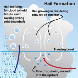
Hail can form in convective systems that extend vertically well into the troposphere and include parts of the cloud below and above freezing. Strong vertical motion in the atmosphere can allow precipitation (hydrometeor) to be recycled up and down through the cloud. As a frozen hydrometeor falls through a cloud and descend below the freezing elevation, melt ensues. Strong vertical lifting (called an updraft) can then take this melted hydrometeor back above the freezing level allowing more condensation and further growth. This process can repeat itself several times as the hydrometeor grows. Eventually, only the outermost layer of the frozen hydrometeor descending through the freezing level melts. The updraft takes the hailstone back above the freezing levels and the outermost layer refreezes and additional condensation occurs. This process can repeat itself numerous times, each time increasing the size of the hydrometeor, basically creating an additional coating of ice with each circulation. Finally, the hail stone becomes too large to be lifted back up into the cloud and comes crashing down to the surface, sometimes violently.
Graupel is really a snow pellet and may be indistinguishable from small soft hail and won't leave any welt in you or your car in its descent to the surface. Graupel is somewhat lumpy and typically occurs when snow partially melts through a layers of the atmosphere above freezing, only to refreeze closer to the surface.
Virga
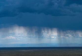
Virga is precipitation that fails the reach the ground. The same processes behind precipitation are associated with virga, except that precipitation falling from high-base clouds into a dry+warm atmosphere may evaporate. Evaporation results in a cooling of the air mass and often downdrafts that bring cooler air to the surface along with winds, sans precipitation. Virga creates an optical effect of shafts of falling precipitation that attenuate before reaching the ground. Virga is quite frequent in southern Idaho and other semi-arid parts of the world.
Log in to BBLearn and, under Module 4, complete "Assignment 4.5: Precipitation Types and Fog."
