The Formation of Clouds
When the relative humidity reaches 100% and the air becomes saturated, what happens next?
There are two possible outcomes when saturation is reached, and the outcome depends on the presence of an important additional component. When relative humidity reaches 100% (usually due to falling temperatures), an air mass has basically reached an energy limit: there is not enough additional heat energy to keep any more water vapor in the gas phase. As the temperature continues to fall and the amount of heat energy available continues to decrease, the next step should be for the water vapor to phase change to liquid water, the process known as condensation. In order for condensation to occur, though, there needs to be an abundance of condensation nuclei in the air -- small specks of dust, salt, or other particles that the liquid water droplets can form around. When these condensation nuclei are not available, the air becomes supersaturated. When they are available, though, condensation occurs, and the millions and billions of newly-condensed liquid water droplets are now visible to us, usually as clouds.
A comprehensive cloud atlas from NOAA is available here.
Clouds are referred to by a set of latin names:
Cirro: wispy, literally "curl of hair" composed of ice crystals and located high in the sky above 20,000 feet
Cumulo: "heap", puffy cotton-ball looking clouds that are formed through convection.
Strato: "layered", flat clouds that blanket the sky. Formed from processes other than convection.
Nimbo: "rain", you guessed it, when this word is attached to a cloud be sure to bring a jacket.
Combinations of these words result in most of the clouds typically seen.
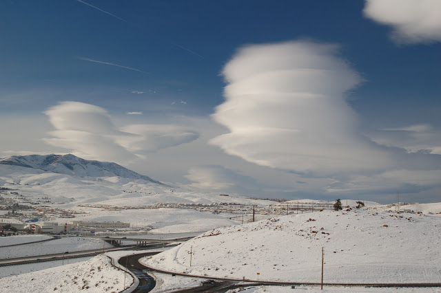
Lenticular clouds are often observed on the leeward side of topographic ranges when there are strong winds aloft, but otherwise stable air. These clouds form as air moves up and over topographic ranges. When air is forced up it eventually cools, saturated and cloud droplets are formed. These clouds are usually stationary throughout the day. Don't confuse with UFOs. Photo above taken north of Reno, Nevada.
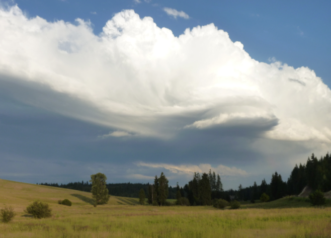
Dark underbellies of clouds indicate that solar radiation is greatly attenuated by cloud and water droplets within the cloud. Typically, such dark clouds are associated with precipitation and hence have "nimbus" somewhere in their name. Non-precipitation stratus clouds that blanket the sky and completely block out any sun can have a similar "dark" look. This photo taken just east of Moscow near Spring Valley reservoir shows a cumulonimbus (yes, puffy rain maker). These clouds are typically driven by convection and thus most frequent when the ground can warm rapidly relative to the surface and tend to build in the afternoon hours. Often times, the lack of any cloud cover in the morning and through early afternoon may enhance the development of afternoon convective build-up by providing strong heating to the ground. Note that the strongest heating of the ground often occurs in the deserts of the southwestern US on completely cloud free days. What extra ingredient(s) are needed to generate cumulonimbus clouds?
Fog is essentially a layer of clouds occurring very close to the surface due to temperature differentials between the air and the ground. Fog occurs when either the surface temperature cools and saturation occurs, or the air mass gets moistened and saturation occurs. Fog occurs in very stable air.
Several types of fog exist:
(1) Radiation fog: occurs as the ground cools rapidly typically in the overnight hours. Often you'll find radiation fog at lower elevations, while the mountains are cloud free. Radiation fog can be particularly nasty in the winter in valleys due to strong inversions that also trap pollutants. Typically seen in the Snake River plain in the winter months.
(2) Advection fog: warm moist air that moves over a cool surface can be chilled and result in condensation. Most advective fog is the result of warmer air moving over colder waters. The key factor distinguishing advection from radiation fog is that advection fog always involve movement. Advection fog is frequent along the Pacific coast of North America.
(3) Upslope fog: moist air moving up a mountain barrier cools to reach its dewpoint. In the absence of additional mechanisms for uplift and cloud development, mountain fog will form.
(4) Evaporation fog: You may see this at a lake surface on a cold morning as warm moist air at the surface contact of the lake is chilled by overlying air mass.
We'd show you a picture of fog, but well, it looks foggy.
Log in to BBlearn and under Module 4, complete "Assignment 4.4: Cloud Patterns."
